GEOGRAPHIC INFORMATION SYSTEMS
Contact Us
6467 Main St.
Gloucester, VA 23061
Phone: 804-693-0129
Email Us
Hours
Monday through Friday
8 a.m. to 4:30 p.m.
Services
Geographic Information System (GIS) is a system that ties features such as buildings, roads and parcels to the information to which it relates. GIS can be used to analyze, visualize and interpret spatial data of all types and sizes.
PLEASE NOTE: Our maps are not survey grade and are not to be used as such. GIS is not the system of record for assessment or ownership information. Please read the disclaimer carefully when navigating to the interactive map.
Addressing
The GIS office is responsible for assigning addresses to new construction. There is occasion where addresses are required on other structures such as garage apartments, workshops, etc. These addresses are reviewed on a case by case instance. This is to ensure the proper delivery of Enhanced 911 service to the citizens of Gloucester County.
How do I obtain an address?
During the construction process, Building Inspection staff inspect the different phases of construction. When the foundation inspection passes, it is flagged and shows up in a report for the GIS Department. This report is usually pulled twice a week and the addressing process begins. Once the address has been calculated, the GIS office will send a written Address Verification Letter to the owner and address listed on the building permit. It can take between 5 and 10 days to generate an address depending on workload. If you have not received notification of your new address after 10 days, please email us at gis@gloucesterva.info.
Grid System
When Gloucester instituted Enhanced 911 in 1993, a grid system was chosen. The beginning number is determined using a pre-ranged numbering grid. Once the start number is determined, measurements are taken and calculated. For every ten feet of road frontage, there is one address number.
Example: 100 feet = 10 numbers. If the center of house A is 100 feet from the center of house B, their addresses would be 10 numbers apart. House A = 5690 My Street Lane. House B = 5700 My Street Lane.
Address ranges are sometimes increasing and sometimes decreasing depending on the direction of the road. If you feel there is an error in the data, please contact our office and we will be happy to look into the matter.
Important Note
Addresses are assigned only to buildings in Gloucester due to the rural nature of the county. Vacant parcels are not addressed.
Custom Maps
Custom Maps are available upon request for $35 per hour, plus materials.
Custom maps are handled in the order in which they are received. Please allow plenty of lead time for your custom map as the workload in our office may vary. This will ensure that we are able to serve you to the best of our ability.
Map Book Contents
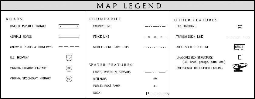
The map book is more detailed than the street map and can be useful in locating specific structures or areas in Gloucester.
The E-911 Response Map Book includes:
Emergency Response District Sheets
Place Name Index
Road Name Index
Route Number Index
Features
Each map sheet may feature addressed structures including, but not limited to:
Apartments
Area Names
Businesses
Churches
Condos
Fire Hydrants
Garage Apartments
Helicopter Landing Areas
Landmarks
Marinas
Mobile Home Parks
Post Offices
Professional Centers
Public and / or Private Roads
Public Boat Landings
Route Numbers
Schools
Shopping Centers
Subdivisions
Transmission Lines


